Tunisia Locations
GPS data
KMZ file containing traces and waypoints
The KMZ file can be viewed using Google Earth. Note: to see all the traces you will need to adjust the timeline at the top of the window. Read the instructions on viewing a timeline to find out how it works.
If you don’t have Google Earth, you can view the KML file in Google Maps.
Guided tour
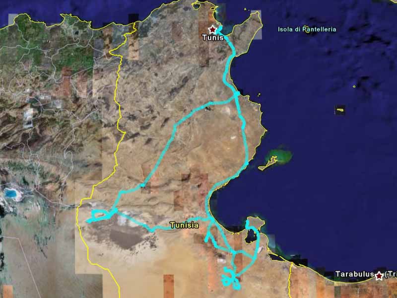
This is an overview of the trip. I encourage you to follow along using your own copy of Google Earth. That way you can zoom into the details and get a closer look at the beautiful landscape of Tunisia.
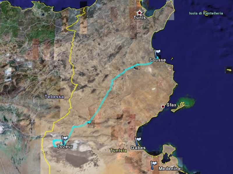
I went to Tunisia at the end of January and early February 2007. The trip started in Tunis, at the northern end of the country. I first went south to the Tataouine area. Then I went to Tozeur in the west. Finally, I went back to Tunis. I spent nine whole days in Tunisia.
The adventure began even before I arrived in Tunisia. I arrived on a late night flight from London, Gatwick. British Airways cabin staff had called a strike for that day. Although the strike was called off, the announcement came too late and many flights had already been cancelled. This meant Gatwick airport, a normally very busy airport, was nearly empty that day. Fortunately, I was flying with a British Airways subsidiary which wasn’t affected by the strike.
Getting through immigration was a novel experience. You have to pay for the visa in Tunisian Dinars, but you can’t get Tunisian Dinars outside of Tunsia because it is a closed currency. What you have to do is leave your passport with them, go through security into the arrivals area, get your money from an ATM, come back through security the wrong way, and then pay for your visa. So I was briefly in the country without a passport. After that, dealing with the taxi drivers was easy.
In the morning, after breakfast, I went straight to the train station to find out when the trains were leaving and to buy a ticket. Except for my first night’s hotel, nothing else had been booked – not even my flight out of Tunisia. This is a great way to travel because you can change your plans as you go: like a place, stay longer; don’t like a place, move on.
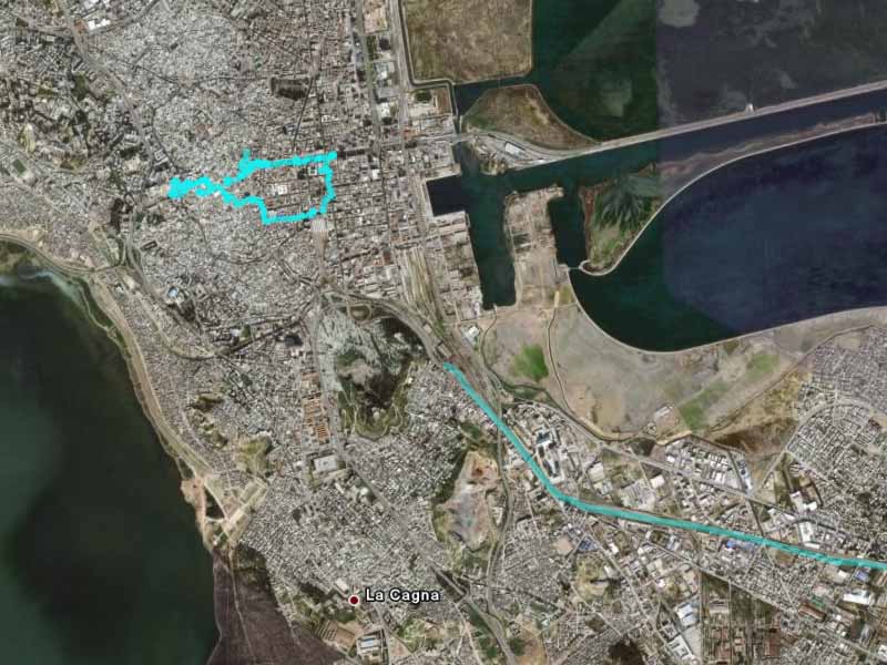
I spent the rest of the morning walking around Tunis. This city was a mixture of old and new. The old part being the Medina, where an ancient walled city is full of twisty narrow lanes and shops. The new part being Ville Nouvelle, where a modern French built suburb lies. In the Medina, you are you are in an ancient arab world. In the Ville Nouvelle, you are almost in Paris, with wide boulevards, cafes on the streets. I was in North Africa, but there were moments it felt like I was in France because they were speaking French and carrying baguettes!
On Google Earth you can see the architectural contrast: the organic historical Median versus the grid layout of the Ville Nouvelle.
I took the early afternoon train from Tunis to Sfax. This was a gentle introduction to the landscape of Tunisia. The city buildings soon turned into industrial buildings, into olive and pistachio groves, into countryside with shepherds minding small flocks of sheep or goats, into desert.
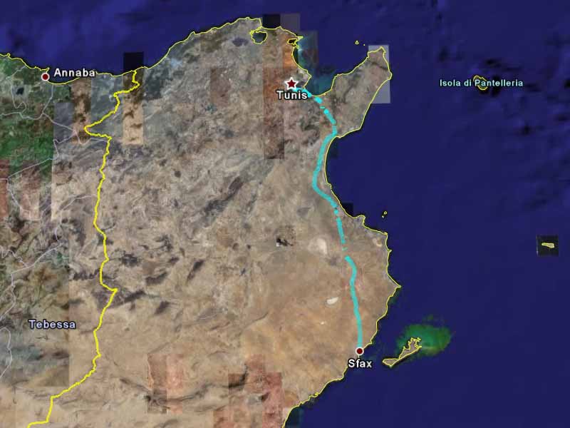
Sfax is a port city, famous for its Medina. The medina had lots of small homes and shops crowded around small alleyways. The Medina was used for some of the Cairo scenes from the movie The English Patient. You can clearly see the Medina in Google Earth.
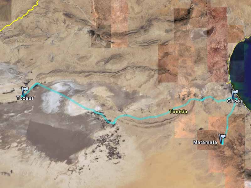
I then took a louage (long distance shared taxi) to Gabes, and then another louage to Medenine. Catching a louage is very easy: you buy a ticket at the ticket booth, find a taxi going to your destination, and wait until it has enough passengers to leave. The system is amazingly efficient, and I never had to wait too long. It is a great way to travel: no bookings required and it was very cheap.
Try to work out where the louage station is from Google Earth (hint: it is where I waited for a short while, so there are lots more GPS points there). If you are really technical, try working out how long I had to wait!
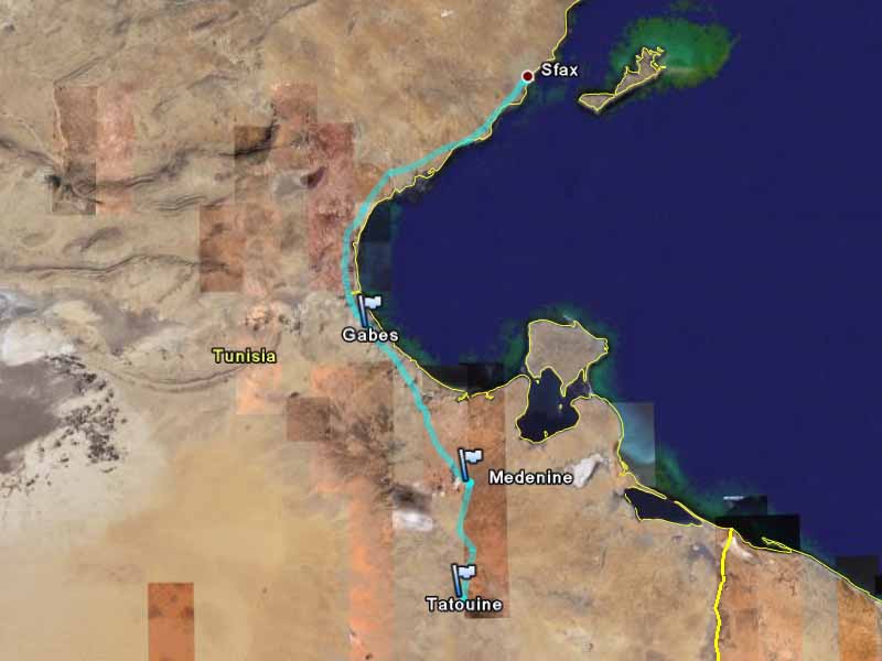
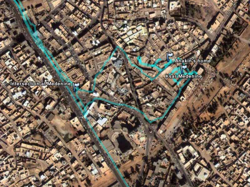
The louage station for Medinine was about 2.5 kilometers out of town. Unfortunately, I didn’t know this when I arrived. I thought it was only a few blocks away, so I decided to walk into town. It was a long and hot walk. However, it was interesting seeing the people and shops along the road. Especially the service stations with homemade petrol pumps made from glass jars.
The main attraction in Medenine is Ksar Medenine, an ancient Berber fortified granary. These are usually built around a courtyard, with the granaries facing inwards and only one entrance into the courtyard.
North of Ksar Medenine is the granary that was the slave quarters in Star Wars: Episode 1: The Phantom Menace. It was used as the exterior the Anakin Skywalker’s home. To find it, you have to walk up the road beside Ksar Medenine and around to the the back of it.
West of Anakin’s home is a small museum. You can see me walking up into the museum, and out again, on the GPS traces. The museum was housed in and around a large set of granaries. They were being renovated, and the museum attendant told me that they were being turned into hotels.
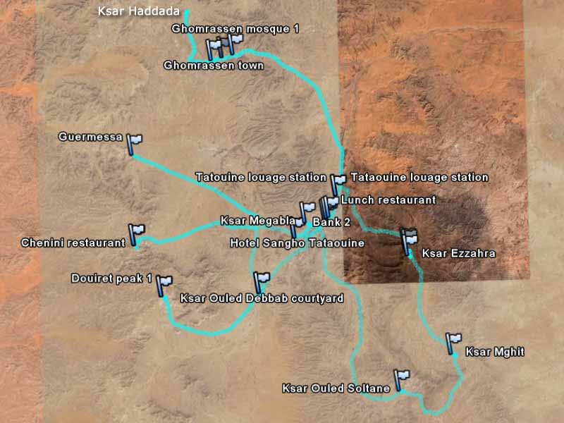
Knowing better, I took a taxi back out to the Medinine louage station. I then took another louage from Medenine to Tataouine, where I stayed at the Hotel Sangho. On the GPS, you can even see where my room was, south-east of the swimming pool. This was in February, the quiet season, so there was only a few other guests staying at this large and very nice hotel.
I got a driver to take me on a private tour of the Tatouine area.
The area in the south of Tunisia is famous for its ancient Berber architecture. There are lots of Kzars, the fortified granaries, as well as ancient hill villages. Some of the Kzars are still in use. However, the hill villages I saw were abandoned ruins. They are well preserved in the southern parts of Tunisia, because of the dry desert climate and because the Romans mainly occupied the north of the country.

The morning was spent in the south and south-east of Tataouine, where some fine Ksour (plural of Ksar) can be found. The most impressive of these is Ksar Ouled Soltane. Ksar Mghit was also impressive. Ksar Mghit was next to a village square which had a small local market. One of the stall keepers gave me some dates, which is a major export for Tunisia.
Zoom in on Kzar Jelidet in Google Earth. The images are very detailed in this area.
We then went north through Ghomrassen to Ksar Haddada. At Ksar Haddada, a few scenes from Star Wars: Episode 1: The Phantom Menace were filmed. Unfortunately, they have renovated parts of the Ksar and that made it difficult to find the filming locations. The place was in the midst of further renovations when I was there, so it might even be less recognisable in the future. According to the guide book, it was previously turned into a hotel that had then closed. It looks like they are trying to have another go at turning it into a hotel.
We drove back to Tataouine for lunch. I had some problems withdrawing money from the ATMs in Tunisia, which is why I marked some of the Tataouine banks in the GPS. I found that I had a very small daily withdraw limit (about AU$100). When I got home I found out that the banks were all using the wrong exchange rate, and so I was reaching my daily withdraw limit with that small withdraw. The difference was refunded immediately, but unfortunately I had to keep hitting the ATMs every day.
The afternoon was spent in the ancient hill villages towards the west of Tataouine. However, before that, there was one more Ksar to visit: Ksar Ouled Debbab. It was very touristy. I suspected this as soon as we drove up and saw a giant model of a dinosaur outside. There was a cafe, museum, and they were also renovating it into a hotel. I was in Tunisia during the quiet season, but it was very difficult to imagine the demand for so many character hotels.
The main hill village I visited was Douiret. It is an entire village built on top of a hill. It was beautiful, with its stone building perched on top of a hill and surrounded by the dry desert landscape. The southern part of Tunisia is a very dry place, as you can see from Google Earth and the photos. In contrast, the north is very fertile, and was called the breadbasket of the Roman empire.
The views from the top of Douiret were amazing. I found two high points at the top of the hill, which is why there are two markers in the GPS data. This village does not receive many visitors, so I had the whole place to myself. I spent a wonderful hour climbing and wandering around Douiret.
Try turning on the terrain layer in Google Earth, and tilting the view to get a sense of the hills in this area.
The hilltop village that most tourists visit is Chenini. We only stopped there briefly. We first stopped at the north side of the village, before driving around to the entrance on the south side of the hill.
We also went to Guermessa, but only viewed it from the road. It would have taken a few hours to climb it, and it was getting late in the day. You can probably spend several days in the area. However, I think one day is sufficient to see a few Ksars and visit one ancient hill village. Note: Google Earth incorrectly labels Guermessa as Douirat.
The final stop was Ksar Megabla in Tataouine. It is not as well preserved as some of the other ones – more correctly, it has not been repaired like the other ones. However, it was good to see the contrast between the different layouts and stages of decay.
The next day, I got my driver to take me to Ajim on the island of Jerba, before dropping me off in Matamata.
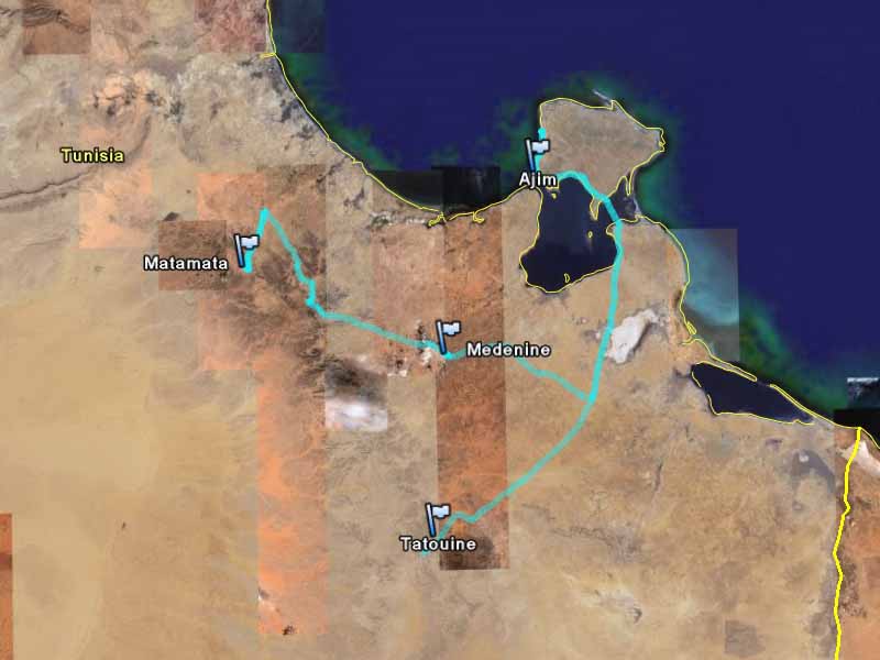
Jerba is popular with tourists, because there are many beach resorts here. We avoided the resort area, but still saw many pottery and souvenir shops along the road. However, we came for a different reason!
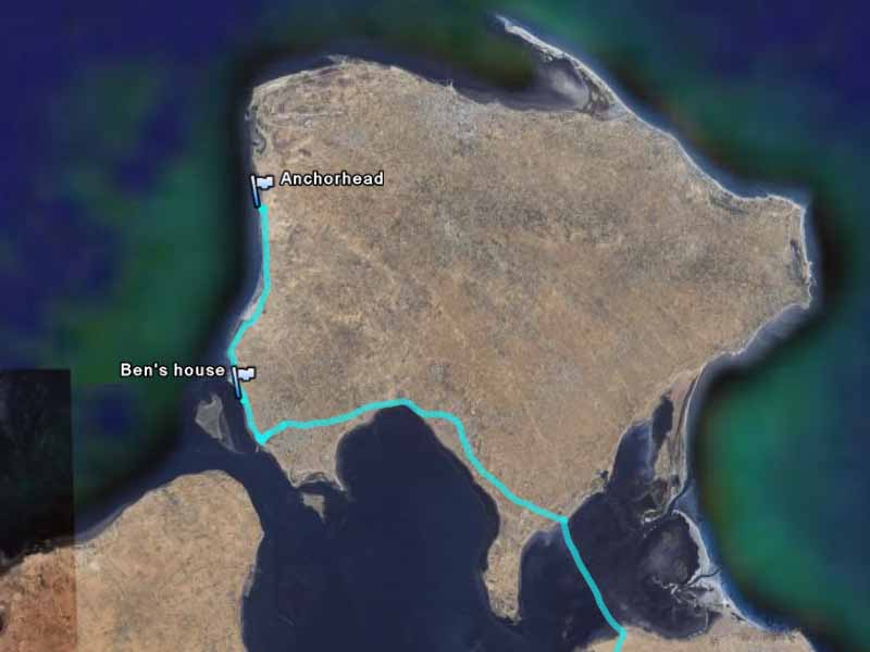
We came to see Ben Kenobi’s house and Anchorhead (more popularly known as the entrance into Mos Eisley). Both of these locations only appeared for less than a second on Star Wars: Episode IV: A New Hope. However, it is amazing that they are still here after thirty years. If you zoom in, you can just see these white buildings on Google Earth. They are pretty easy to locate, since they were the only few buildings along that side of the island. They are isolated and only accessible by a sandy dirt track.
You will be surprised to discover that most people in Tunisia don’t know anything about Star Wars. My driver was the same, and he couldn’t understand why we went to Jerba to see two obscure buildings! There are a few more filming locations in Ajim, but I didn’t know exactly where they were and I think it would have tested the patience of my driver trying to find them.
There is a ferry from Ajim to the mainland, but we left the way we came (via the causeway in the south-east of the island) because we didn’t want to wait for the ferry.
We stopped in Medenine for lunch. Then we went the back way, through the mountains, to Metamata. The mountains were covered in low lying shrubs which grew along the layers of the rock sediments, creating a beautiful contour map like pattern that covered the landscape. However, the roads were less beautiful: being dangerously narrow and covered with rough gravel. You can get a sense of the terrain and the plants on Google Earth.
In Matamata I parted with my driver.
Matamata is famous for its underground dwellings. From Google Earth, you can see many holes that are people’s homes. About 1km north of the city there was a large set of letters spelling out the name of the city on the side of the hill. We stopped there for a photo. You can read the letters in Google Earth.
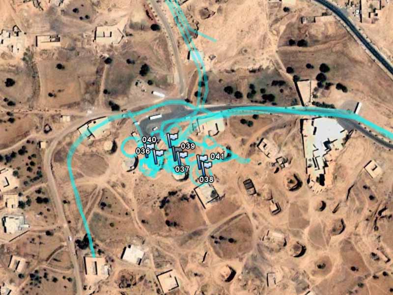
The famous Hotel Sidi Driss is in Matamata. It served as the interior of the Lars homestead. You can see the GPS traces of me walking around the edge of the craters that make up the hotel. I stayed overnight in the hotel. This was definitely the quiet season, because I was the only guest in the hotel that night.
This morning, I awoke to find a thick blanket of fog hanging over Matamata. Good conditions for a moisture farm, but not so good for taking photographs.
I met an Australian guy called Wez at Matamata (he stayed in a different hotel), and he kindly gave me a lift to Gabes. We drove around downtown Gabes in search of an ATM, before he dropped me off at the louage station.
Gabes is famous for its date palm plantation. In Google Earth you can see the plantation that makes up nearly half the city. From Gabes, I took a louage to Kebili and then another louage to Tozeur.
Tozeur is the tourist hub of western Tunisia. To cater for the tour group traveller, there are many luxury hotels (with prices to match) in a “tourist ghetto” area in the south-west corner of the town. However, I stayed at the Hotel Continental in the normal part of the town.
After checking in, I wandered around town and tried to find a tour that will take me to the Star Wars filming locations in the area. Unfortunately, the only tours available went to normal tourist attractions and the Mos Espa set (which they simply called “The Star Wars”). So that night I decided to take matters into my own hands and rent a car – I didn’t come all this way to be limited by what the tours can offer. However, this was going to be a big challenge: firstly because driving in Tozeur is pretty chaotic; and secondly because I didn’t know exactly where these filming locations were!
In the morning I rented a car in Tozeur. The hotel recommended a local car rental company which gave me a small Fiet. It was strange signing a rental contract in French which I couldn’t read.
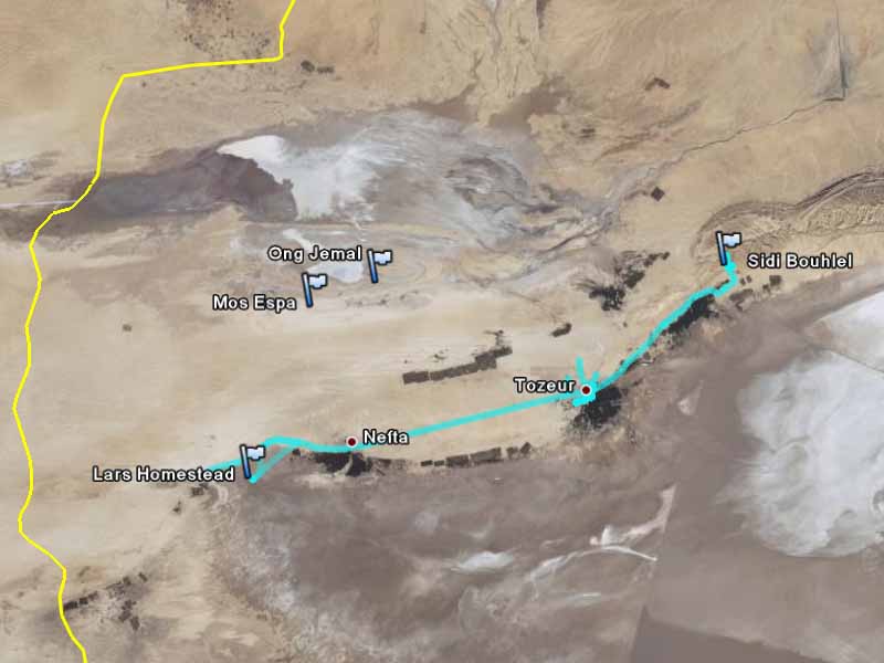
In the morning I drove east to Sidi Bouhlel. In the afternoon I drove west towards Nefta.
Near Sidi Bouhlel is the famous Star Wars Canyon. Not only was Star Wars filmed here, scenes from Raiders of the Lost Ark and the English Patient were also filmed here.
Finding the Sidi Bouhel car park was very easy. You drive on the main highway towards Kebili. Just before you enter the Chott el Jerid, take a left turn at a road with a sign saying “Dghoumes”. About 2.1km along this road, turn left and drive for another 1.6km. You can’t miss it, because the car park is a huge gravel covered area at the end of this road.
The canyon was difficult to find. You can see me wandering to the north-west and to the east of the car park in search of the canyon. I figured out that east was not the right canyon and was taking a photograph of the desert landscape when all of a sudden a man approaches me. I was in the middle of nowhere and someone appears. Fortunately, it was a local guy called Sherif, who then spent a few hours showing me the canyon and the filming locations in it. He didn’t speak much English, but with charades he acted out which scene was filmed in each location. We first went along the top of the east side of the canyon, before descending into the canyon and walking back down inside it to the car park.
The canyon walls seemed to play havoc with GPS signals, so some of the GPS traces are a bit inaccurate.

After Star Wars Canyon, I drove back through Tozeur to Nefta in the west.
West of Nefta is the exterior of Lars homestead, but finding it is very difficult. West of Nefta, immediately past a police checkpoint you turn left off the road. There is a large stall set up here to sell desert roses and other local souvenirs. You can almost make out the stall from Google Earth. Near to the souvenir stand is a road block that says, “do not drive past this point.” As I drove around the road block, I looked back to see if the police are going to do anything about it. They didn’t. However, I soon realise why the sign was there, because you can easily get lost in the totally flat and featureless landscape of the salt lake. Thankfully, I had my GPS with me.
The Lars homestead is a small igloo and a few artificial craters. This is not the original igloo, but one that has been recreated for the filming of the prequels. This was the exterior of the Lars homestead, whereas the interiors were shot in Matamata – hundreds of kilometers away.
Visit the Lars homestead in Google Earth with this 3D model of the Lars homestead.
Driving back through the flat featureless landscape, I followed the wrong track and joined the main road much closer to Nefta. It’s very easy to get lost on the featureless salt lakes. I then went back to the police checkpoint; I’m sure they were surprised to see me again. This time I turned right off the road, and headed up north to the beginning of the La Grande Dune. Some of the Tatooine desert scenes in Star Wars: Episode IV: A New Hope were filmed in the Grand Dunes. There were camel rides here to take you to the Grand Dunes. However, since I was short on time, I simply took a few photos of the area and left.
I drove a few kilometers west on the main road, before heading back to Tozeur. From the side of the main road you can just see the Lars homestead. However, it is very small so you have to know where to look.
This was a very productive day. I made it to Star Wars canyon and the Lars homestead – both places which the tours didn’t go. However, I haven’t been to Mos Espa. What do I do: take a tour, give it a miss, or try and find it myself?

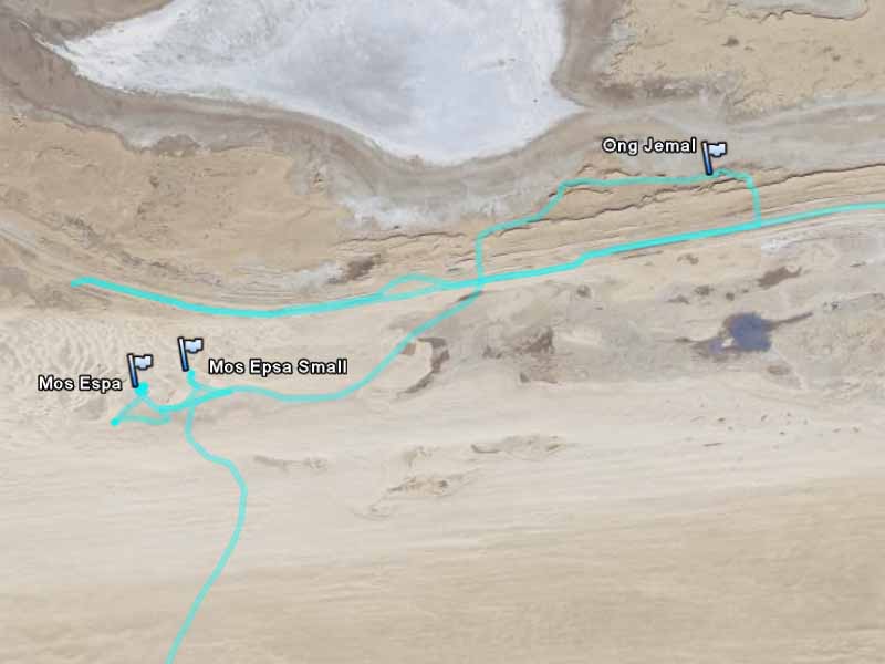
The next morning I decided to set out to try and find Mos Espa. I had no idea where it was, other than it was out in the Chott el-Gharsa salt lake somewhere to the north-west. I wasn’t sure if I could find it nor what the road conditions were, but since I came all this way I should give it a go. Obviously, the desert is not something to take lightly: I took plenty of water and I would have turned back if the road conditions looked bad. Although I didn’t know where I was going, I had my GPS so I could always find my way back out. I would advise everyone visiting this area to use common sense. The desert conditions do change, so you might consider getting a four wheel drive to be on the safe side. Since I had to return the rental car that morning, I started out before sunrise. I headed north from Tozeur, past the airport, following the signs to Ong Jemal.
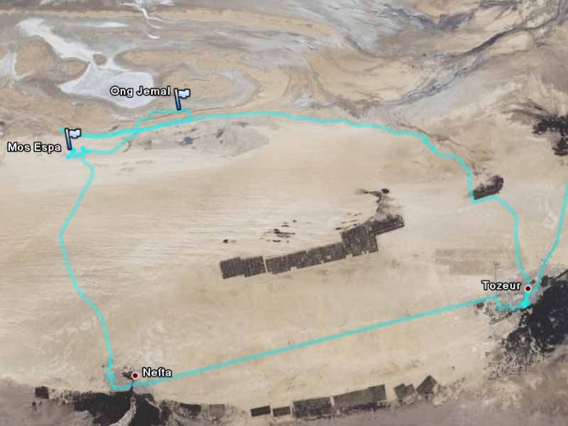
The signs in the city gives you a false sense of security, because soon there were no more signs and just unmarked dirt tracks. I kept on what looked like the main track until my instincts told me that it can’t be this far away. It was a good thing, because if I had kept on going west I would have ended up in Algeria without a visa–and that would have been very bad.
After turning back, I decided to take one of the unmarked tracks heading north. This track then turned towards the east, and I was surprised to find myself at Ong Jemal. This is a curiously shaped hill, which is why the place is called the “neck of the camel”. There were no signs, but recognised it from the postcards I have seen in Tozeur. I also recognised some of the hills from The English Patient (which I watched as part of the “research” for this trip). The road returned to the main track, and this time I took the turnoff heading south-west off the main track. I soon drove around a sand dune and felt a great sense of accomplishment at seeing Mos Espa spread out before me.
Mos Espa is an entire set built in the desert for the filming of Star Wars: Episode I: The Phantom Menace. There are two filming locations here: the large Mos Espa set and the small Mos Espa set. It’s a very impressive place to be, with many building facades and moisture evaporator props.
Visit Mos Espa set in Google Earth with this 3D model of Mos Espa large set.
When I was there, only a few corners of the small set was visible. The rest was covered by the sand dunes. I was subsequently told that a few years earlier it was totally covered up, so it seems to be emerging from the sand dunes.
After spending some time here, I drove south from Mos Espa to return to Tozeur via Nefta. One of the locals hanging around Mos Espa wanted a lift to Nefta, and he showed me this way (otherwise I would have never found this track). Note: this track is very sandy, and one can easily get bogged here. The sense of accomplishment could have easily been replaced with a sense of disaster, but the car made it through. I even brought the rental car back with less than a minute to spare! This was another successful day.
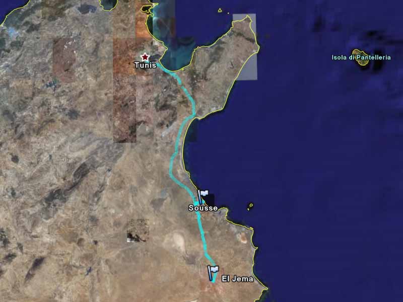
Back at Tozeur, I caught a louage to Gafsa, and then changed to another Louage to Sousse. This was a long trip. However, after the Mos Espa adventure, I was happy to spent the rest of the day sitting in a louage and let someone else do the driving.
Sousse was a shock. It is a normal modern city on the Mediterranean Sea. It has resort hotels along the beach. However, I found it rather strange being back in a western style city. The things I was familiar with (shops, advertising, and city life) seemed very odd after spending only a couple of days in the desert. It was nice to be back, but it felt really strange.
I stayed at the Hotel Sousse Palace, where my room was huge, luxurious, and had ocean views. It was nice being back, but it was also sad knowing that my trip was nearing its end.
The next morning I caught a train from Sousse to El Jema.
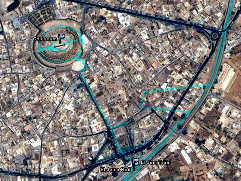
El Jema is famous for a wonderfully preserved Roman colosseum. Not only is it well preserved, but visitors are allowed to walk all around and through it, as well as downstairs where the animals were kept. The GPS traces shows me walking around the outside and arena of the colosseum.
I then took a train back to Tunis.
In Tunis, I bought an airline ticket to leave the country. Originally, I had hoped to take a ferry to Italy, but that didn’t work out: the ferry timetable didn’t fit, the trip would have taken a long time, and it was quite expensive.
My last two nights was spent in the Grand Hotel du Lac. An amazing piece of architecture that looks like an upside down pyramid–small at the bottom and big at the top.
My last whole day in Tunisia was spent in and around Tunis.
I first went to the Bardo Museum. It is a wonderful museum, with a very impressive collection of Roman artefacts housed in a spectacular building that was once a palace. The Roman mosaic collection is spectaclar, and well worth seeing.
In the afternoon, I caught the TGM train out to Carthage. Once a city in its own right, but is now a wealthy residential suburb of Tunis.
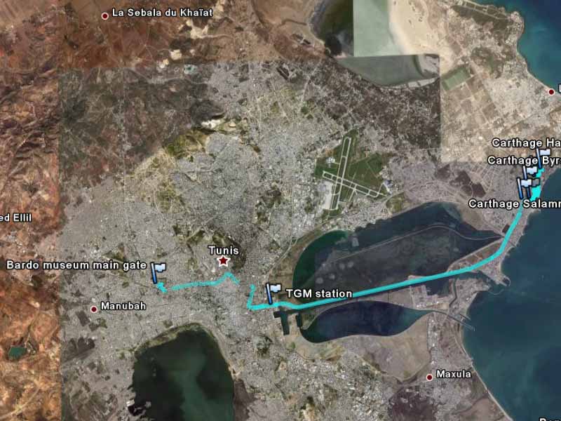
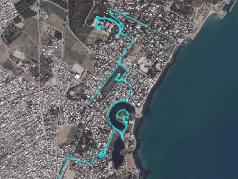
Carthage was one of the great cities of the ancient world. It was the center of trade and its power dominated the Mediterranean. Its warships were housed in a circular naval wharf, which you can still see today. I walked around it, before heading up to the church and museum at the top of the hill. Afterwards, I took the train back to Tunis.
The next day, I flew out of Tunis to Rome. It was a quick trip, but I think the pace was about right: most towns only had one or two major attractions so staying longer in one place would not have been useful. If I had more time, I would have spent a whole day in Carthage (instead of just an afternoon), spent more time in Ajim looking for the filming locations, and maybe one extra day in Tozeur. There were many things to do in Tunisia, but I think my quick trip covered nearly everything I wanted to see.
Tunisia is a wonderful country to visit. It has interesting historical sites and beautiful (in its own way) desert scenary. It was very inexpensive and it was easy to get around. The people were friendly and I thought it was a very safe place to be. I really enjoyed my time there.